Thursday, August 18, 2011

Mental Map


Ever since in architecture school, the process of mapping (reading and drawing plans) has been a frequent one. In these years, the little architecture of the world that I have exposed myself too, figuring spatial patters, etc. has been more than an interest, a habit. It would be very difficult to detach it from my perception today, free myself of the prejudices that my mind has, when I look at places now. So, I chose to map, my place of residence for 14 years, an industrial housing colony, sitting in an anonymous piece of rural India before I moved to the city when I was 15. I was not born here but started walking here and spent my formative years in this self sufficient oasis in the middle of nowhere, but that part didn’t matter to me so much.

The things about the place I remember the most were, perhaps, the ones that were suddenly taken away from me by the bigness of life city. Every morning, we would leave for school at 7:30 AM from my home, for school that began at 7:40 AM. We would walk (run usually; I have always had a major punctuality issue). The shortest walking path to school would cut across through the employee’s Club House and garden, pass by a different row of houses and a little piece of land always shaded in a thick canopy of trees. And on your way, you’ll meet all your friends from the neighborhood. Everyone (mostly) was your friend. Everyone, at least knew everyone. There was ease. There was familiarity (or maybe I just got used to that life). Mostly, everything was at walk able   distance, clean metalled roads (only the main ones two lane) with virtually no cars. We only needed to drive to the nearby city (an hour and half away) to buy clothes and other things that the local market won’t keep (for example Hershey’s chocolate syrup). Cycling in town was easy; I would cycle to my math tuitions in the other side of the town.

The journey to my math tuition was the only time I would venture into the ‘other side’ of town. As soon as I would cross the main road, it would start getting unfamiliar (not uncomfortable though), the density of houses increased while their sizes of plots and front gardens shrunk. Except for a few school friends’ homes, I can’t recall the rest of it today. But I remember the main road being wide enough to notionally cut across the sparse settlement. I faintly remember it being two lane, but giving an impression of four. But along with that opinion also appears the fact that all public utilities, the main market, the hospital, the bigger school, the swimming pool, the stadium, the auditorium, the main temple, the Durga Puja grounds, were all along this main road, the central axis that brought the two towns together, I realize on afterthought. It dawned on me only recently; the dynamics of designing Industrial townships, providing inclusive living environments for the both the executive and technician designations, and the place didn’t do a bad job of it.

 The main road would also transform into a linear Mela ground, during the time of Dussehra, the only time the nearby villagers were allowed inside the tall boundary walls. The walls were tall enough to never let us see the other side of the story, and only use imagination to paint the picture. It gave a sense of protection and insecurity at the same time, perhaps the latter more intensely than the former, a peculiar but distinct memory. But outside the gates were also the subzi mandi and the sugarcane juice wallah that our parents would take us to, once in a blue moon. Despite the main market stocking all consumables, an occasional trip to the mandi was certainly refreshing, perhaps our only encounters with the realities of earthy rural (natural) life. Going too far away from the sight of the main gates would also be intimidating too, only increasing the unfamiliarity and discomfort factor exponentially.

Familiarity was in the linearity of things around, the rectangle-ness, of the single storey bungalows with front and rear setbacks the size of the apartment I live in presently, in the comfort of single lane roads lined with big trees on either side, and hierarchy that it followed for more public areas (whatever we later studied to be the ideal Grid iron pattern of settlement layout), in the uniformity in the color combination that every house was painted in. in the same window grille design and door handles for every house, so shifting houses didn’t hurt that much.

What surprises me the most is the fact that, today in the apartment block I live in, my comparative physical proximity to the neighborhood has increased potentially, but it has only inversely reflected on my social interaction with my surroundings.  Was it the success of everyone’s parents working with the same company? Was it the lack external engagement opportunities then? Other complicated planning theories and principles that affected my behavioral patterns as an individual growing up in the neighborhood? Or, simply put, am I just not a kid anymore?

Rohan Patankar

Thursday, December 23, 2010

UNTITLED SQUARE II

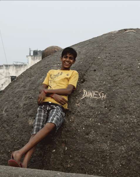
Who is Dinesh Chodhary?

During the search for the missing linkages between Khirkee and its neighborhood surfaced these childhood memories of every adult of the locality, memories of coming to the monument to play, study or just to meet up and chat, and the monument being a part of their lives, even if a dormant one. Still living those memories, 14 year old Dinesh, Ashish, Varun and their friends spend a few hours of their day at the monument daily and feel this unexplainable connection towards it that brings them back to it. The most dominant of the lot, Dinesh Chodhary asserts that he owns the monument. “Yahaan mera Raaj hai.” Like the bats occupying the ceiling of the monument that line the floor with mounds of their dung, the dogs who live in the monument and bark off unwanted visitors, every adult of Khirkee village who has spent a part of their childhood flying kites on the roof of the monument, playing hide and seek or just coming there to contemplate, Dinesh Chodhari is the embodiment of everyone who tends to claim their ownership on the monument in their own little way. Through the 700 years of its existance, people have come and gone and developed and proclaimed their relationship with the monument and different ways each time.


And the Dog ate the art..

To see if this 700 year process of the monument’s setting undergoing dynamic change could be scaled down to overnight and replicated, an experiment was carried out.  The symbol for the monument, a pink paper square as depicted in the DDA Map (which interestingly the kids identified in no time) was pasted on a white paper context with help from Dinesh and his friends. And the ‘paper Khirkee’ was left on the rooftop overnight under the supervision of the ‘owner kids’. The kids drew and wrote all over, unsurprisingly, Dinesh occupying the centre place. By late evening, as Dinesh recounts, the kids were confronted by a group of drunkards who just wanted to take the ‘Chataai (mat)’. The kids, overpowered and intimidated, pulled the pink monument off the white and ran away. Dinesh says,”baaki sab to phir se banaa sakte hain, yeh phir se kaise bantaa! (Everything else could have been made again, this could have not been!)”. The next morning, the ‘everything else’ was found all over the monument in tatters, some being chewed by the resident dogs. Through the night, the context of the monument kept changing and everyone, from Dinesh to the drunken men and the dogs claimed it in their own ways. But the monument lived on bearing a multitude of associations but still being anonymous and unnamed.


Dinesh (in purple) explaining the series of events on the Open Day 


UNTITLED SQUARE THUS

Our personal assumption that the monument stands neglected in the void of time amidst unfamiliar apathetic people was shattered. For what may seem like a perfect case of de-contextualization of the monument to its ever changing context, it was felt that the association of people with the monument was a far more vital linkage to which even the monument lent itself differently through time. The sense of claiming a space rather than actual ownership of it has kept the spirit of the place alive despite the ambiguity in its purpose. In fact, the apparent anonymity reinforces the people’s personal assumptions. In such a controversial and sensitive fabric, the neutral role assumed by the ASI is only helping keep the equilibrium of the place, making room for conflicting convictions to coexist. The beauty of this bustling urban village lies in the Khirkee monument forming a backdrop to all human activity and remaining conveniently untitled for only the better of the community.


Photographs Credits: Vidisha Saini 

Wednesday, December 22, 2010

UNTITLED SQUARE I


UNTITLED SQUARE: A project initiated by Rohan Patankar and Vidisha Saini
as participants of URBAN TYPHOON a KHOJ-URBZ collaboration workshop held in New Delhi in November, 2010.


KHIRKEE: Untitled Square

The epicenter of Urban Typhoon 2010, The Khirkee village in Delhi draws its name from the Khirkee monument, a 700 year old stone structure, generally accepted by historians as a 14th century mosque, built by the prime minister of Firuz shah Tughlaq, one of the most zestful builders of the Tughlaq dynasty in Delhi. Today, the ruins of the monument, the source of the settlement, stand within a 10 ft high fence seemingly disconnected from their context, the bustling urban village of Khirkee,


MASJID
Walking around Khirkee, trying to uncover the layers of time and history accumulated over monument and the settlement, one suddenly chances upon the Delhi Development Authority’s Guide Map of Khirkee Village where the monument figures as Pink Square in the middle of the village plan. Interestingly, it is clearly evident that the square was labeled as the Masjid and later the labeling painted over on both the square and the index. Further investigation reveals that the majority composing powerful Chauhan population believes the monument to be an extention of Qila Rai Pithora, a 12th Century Chauhan Fort, constructed by Prithviraj Chauhan one of the last Hindu Kings of Delhi. Long ago, Khirkee village was resided by an equal number of Chauhan Hindus and Muslims, but post partition migration led to the concentration of Hindu population in the village as the Muslims left for Pakistan.

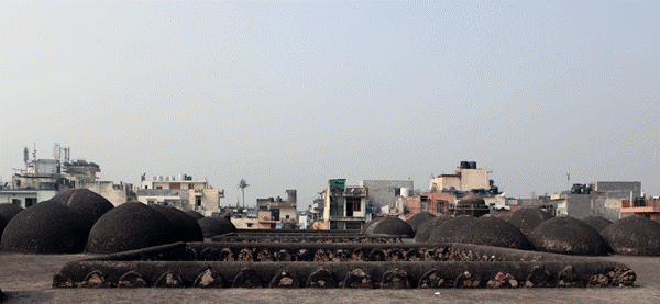
Rooftop of the Khirkee Monument


UNTITLED?
The massive looking random rubble masonry, turret like minarets on its four corners and covered colonnades cutting through the square courtyard (unlike most mosques) only reinforce the Hindu Fort assumption, conveniently so for its present neighborhood. There is no written record or verbal memory suggesting the use of the Monument either as a mosque or a fort. In all this conflict, the monument, declared Protected by the Archaeological Survey of India, is inaccessible to public for active use such as praying and presently does not even bear a descriptive write up board at site. The learned elderly of the community refer to it as the ‘Khirkee Building’. The Square Plan of the monument is Untitled for the anonymity that the ASI gives it and the ambiguity the community has evolved around it. But do uncelebrated spaces at the helm of dynamic communities really remain untitled? Does the sheer presence of a 700 year old monument in the neighborhood not affect the residents? We set out to find. 

Sunday, November 28, 2010

An Architect

Case studies of an Indian and a foreign architect for theory of design
Architects: Delhi based Pradeep Sachdeva and Tokyo based Kazuyo Sejima (SANAA)
https://docs.google.com/viewer?a=v&pid=explorer&chrome=true&srcid=0By47gZwtjiAPZTkzZDc0ZWUtYzIxMS00MmUwLThhZWQtOWY1YjBiYzYzMWVj&hl=en

Friday, October 29, 2010

Agra: Past and Present

"Agra: Past and Present" is a presentation done by Rohan Patankar, Varun Bajaj and Virkein Dhar of B.Arch IIIrd year, Section A. Here is the link: https://docs.google.com/fileview?id=0BxvEmaAOdTfqMWYxODBjYjAtMTk4MC00MmRkLWJhMmYtZjQyODlmZWMzNGFm&hl=en&pli=1


Bibliography:
Thesis in Architectural Conservation by Bhatnagar, SPA, 1993
Thesis in Urban Design by Shaheena Khan, 2005
City Development Plan, Agra, August 2006

All photographs have been taken by the authors